Developed through a joint collaboration between the American Land Title Association (ALTA) and the National Society of Professional Surveyors (NSPS), the 2026 ALTA/NSPS Guidelines have been released and will take effect on February 23, 2026.
This 11th edition includes eight sections and updates to Table A Optional Items. Most revisions focus on tightening and clarifying language and improving surveyors’ field procedures with minimal anticipated impact on project timelines or costs.
Below are highlights of the changes most relevant to commercial real estate professionals.
4.C. Record research responsibilities
Under the new standards, record descriptions of adjoining properties are no longer required to be provided to the surveyor by the party placing the order. As a result, surveyors will now be responsible for independently researching and obtaining record descriptions of adjoining properties through desktop research, using information available from county records.
This change reinforces the surveyor’s role in certifying legal boundaries and helps improve accuracy and consistency, particularly in situations where a title commitment is not provided, such as certain boundary surveys. By relying directly on public records, surveyors can better identify and evaluate potential boundary issues.
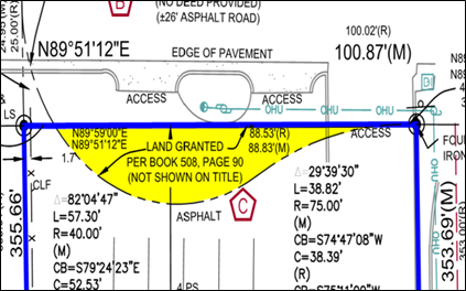
Two common examples of boundary discrepancies, also referred as areas of confusion, include overlaps and gaps:
• Overlaps occur when two separately dated parcels or surveys partially encroach on one another. The example below illustrates when a surveyor notated an overlap, shown in the yellow highlighted area.
• Gaps occur when survey lines do not fully meet, often due to language inconsistencies or ambiguity in a deed.
When record discrepancies exist, they can lead to disputes or legal complications. The updated standards aim to reduce these risks by ensuring surveyors conduct thorough, independent research of adjoining properties. When discrepancies are found, the surveyor will first contact the title company to reconcile their findings before notating them on the survey.
If a prior title record or deed is provided at the start of the project, these changes do not result in a cost increase for the client. If no historic information is provided to the surveyor and the surveyor is burdened to perform the title research, the scope of research may incur a fee.
5.A.i & ii Note existing monumentation and its relationship to the ground
Under the new standards, all found monumentation must clearly indicate its relationship to the ground surface. Appropriate abbreviations—such as AG (above ground), FL (flush with the ground) and BG (below ground) or similar—must be included in the survey legend to identify this condition. A monument can be any object of a permanent nature used to mark a boundary. Common examples include rebar, iron pipes, concrete monuments, aluminum caps on rebar, spindles, shotgun barrels, axles, mag nails, marked trees, stones, and nails with caps.
These changes in 5.A.i & i do not result in a cost increase for the client.
Not to be confused with Table A. Item 1, placing/setting monumentation. When Table A Item 1 is ordered, it will result in additional cost and lead time because this is a new scope of work and may require an additional field visit. All new monumentation, along with its relationship to the ground surface (flush, above ground, or below ground), must be clearly noted in the survey.
New Table A. Optional Item 20: Summary of Possible Encroachment
Table A Optional Item 20 is regarded as a summary table or a highlights table. As a reference tool, the table presents key facts and highlights potential concerns in a clear, accessible format for readers who may not be familiar with how to interpret a survey. Surveyors are asked to report factual, physical conditions based on their observations and are not providing legal opinions. The content is taken verbatim from Sections 5 and 6 and organized into a summary format.
Because this is an optional item, selecting Table A Optional Item 20 will result in an additional scope of work and associated fee for the client.
Other questions most relevant to guideline changes:
1. Is there any cost difference in the new guideline changes?
The changes are not substantial and would have minimal impact on costs and lead time.
2. I have a transaction deadline around February 23, 2026, what should I expect?
February 23, 2026 is a hard deadline. All surveys completed and stamped on or before this date will follow the 2021 guidelines. Any surveys completed and sealed after February 23, 2026 will be prepared under the 2026 guidelines.
3. I completed an ALTA survey 6 months before February 23, 2026, what should I expect?
Once a survey is finalized and sealed, it is considered complete. Any survey sealed on or before February 23, 2026 is prepared in accordance with the 2021 ALTA/NSPS guidelines. If a new survey is required after that date, it will be treated as a new project and will require a new field visit and incur appropriate fees.
An ALTA/NSPS Land Title Survey is a standard requirement for most commercial real estate lenders. Partner Engineering and Science is a qualified consultant recognized by national lending institutions. Partner’s survey experts provide comprehensive land survey coordination services, guidance on current ALTA standards, interpretation of recent guideline updates, and oversight to ensure surveys meet lender, title, and transaction-specific requirements.
In preparation for the upcoming guideline changes, Partner will host a nationwide virtual webinar on February 3, 2026. The session will provide practical insights into ALTA survey coordination, technical surveying standards, and best practices for due diligence, offering a well-rounded perspective on managing risk and meeting transaction requirements with confidence. Register today.
Please contact Partner with any survey-related questions. Our team is available to assist.
© Arc, All Rights Reserved. Request academic re-use from www.copyright.com. All other uses, submit a request to TMSalesOperations@arc-network.com. For more information visit Asset & Logo Licensing.